")
AzVision.az presents the maps and atlases dating back to the period of the Russian Empire and different times of the Soviet era. There are maps of various purposes (military, topographical, physical, administrative), but useful to see how toponyms were renamed from time to time.
One of the first maps published after the annexation of the South Caucasus to the Russian Empire is the “General map of the Caucasus region” dated 1858. The map was published by Military Collection , an official monthly magazine of the Ministry of War (Military Ministry) of the Russian Empire from 1858 to 1917. The magazine was also read and praised by Emperor Alexander II.

It was no coincidence that one of the first maps published by the military magazine was dedicated to the Caucasus. A detailed map of the newly annexed region of the Russian Empire was needed.

As is seen from the map, the western part of the South Caucasus (Transcaucasia) was divided between 3 governorates: Shamakhi, Tbilisi, and Iravan. Their administrative borders are marked by a thick dark-green line (do not confuse the Kur River, flowing through the middle of the Shamakhi Governorate, with the borderline). The territory, currently known as “Karabakh”, together with the southeast (i.e. Zangezur region) of present-day Armenia, belonged to the Shamakhi Governorate. There is no mention of any administrative trace of Armenians there.

If we look at the map very carefully, we can see Shusha, a major city in the region, and the road connecting it with Ganja (Yelizavetpol). Next to Shusha, the name of a smaller settlement is mentioned: “Ханъ-кенды” and “Ходжалинская”.

Let’s recall that this map was published in 1858 by the magazine of the Ministry of War (Military Ministry) of the Russian Empire. If the Russian Peacekeeping Contingent, temporarily stationed in Azerbaijan’s Karabakh region, “respects toponyms”, they should once and for all stop using the word “Stepanakert” and describe this territory with its true name - “Khankendi” as it was done by their predecessors in 1858. Such a move would also be respectful to their grandfathers.
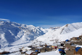
Taking a look at the territory of present-day Armenia on the map, it can be seen to what extent how toponyms were renamed and distorted. The name of Goycha Lake was originally written in the Azerbaijani version. Alagoz mountain is mentioned only in the Azerbaijani version.
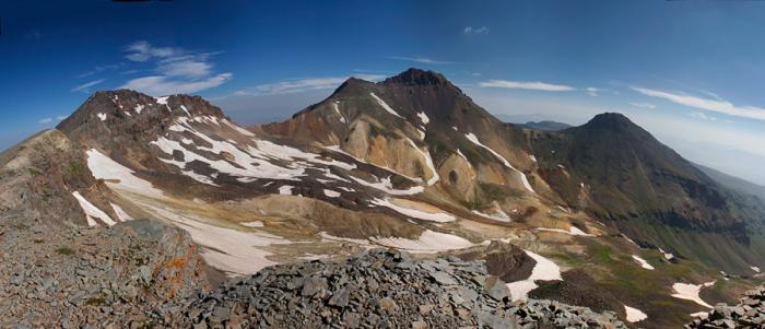
Alagoz Mountain
Alagoz mountain is the highest peak (4,095 meters) on the territory of present-day Armenia. Armenians call it “Aragats” and link its name with Tsar Argishti of Urartu. However, 160 years ago, the mountain had only one Azerbaijani name - “Alagoz”, what a beautiful name it is.
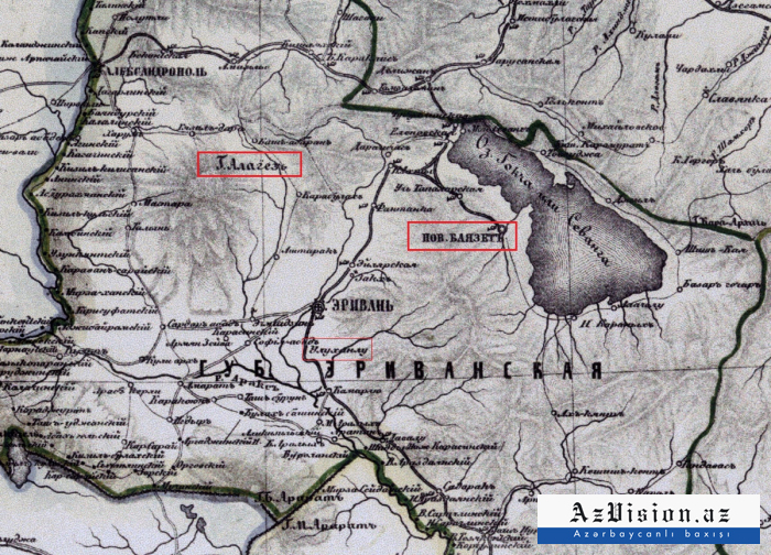
The “Yeni Beyazid” settlement next to Goycha Lake immediately attracts attention. The marking system of the map reveals that it was a large settlement for that period. There is no settlement in that place on the territory of present-day Armenia. Now there is a small town of Kavar (Gavar) near that area (it was called “Kamo” during the Soviet period).
The map of 1858 also mentions numerous Azerbaijani-Turkic toponyms around Iravan. They are countless: Ulukhanli, Kemerli, Garabulag, Serdarabad, Gozeldere, Bulagbashi… All of them are clearly visible on the map!
Those who are deeply interested in this topic and want to study the map independently can contact our editorial office to receive its large image (10499*8642, 142 MB).
Part II will present another interesting historical map.
Vusal Mammadov
AzVision.az
More about: