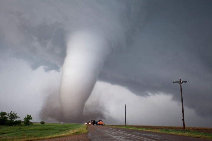
Twisters have ripped through communities across the U.S., killing at least three in Missouri last week, injuring nearly 100 on Monday in Ohio, and upending thousands of people’s lives. On Thursday, nearly 78 million Americans still faced increased odds of tornadoes touching down, according to the Storm Prediction Center, including major metro areas like New York, Washington, D.C., and Nashville.
The outbreak of twisters over the past two weeks has already put U.S. tornado numbers well above average for this time of year. And the same pattern that has helped spawn so many tornadoes could still be with us through the end of the week. Though they didn’t see exactly where each tornado would touch down, researchers have been eyeing this pattern weeks ahead of time thanks to an area of strong thunderstorms thousands of miles away in the tropical Pacific.
May is prime time for tornadoes to hit the U.S. as storms come rumbling out of the Rockies and warm, moist air gets sucked up out of the Gulf of Mexico. But even by May standards, the number and especially the geographical extent of where tornadoes have touched down has been notable.
“We’ve had one of the most active stretches on recent record,” John Allen, a tornado researcher at Central Michigan University, told Earther. “Thirteen days is pretty impressive.”
Indeed, the U.S. has seen roughly 600 tornadoes reported since the start of May with most of them coming in the last two weeks of the month. Some of those reports are duplicates, and it will take the National Weather Service some time to sort out a likely lower official final count. But regardless, scientifically speaking, there have been a crap ton of tornadoes.
Harold Brooks, a senior scientist at the National Severe Storms Laboratory, told Earther that while the final tornado count is still a ways away, the late April 2011 and May 2003 outbreaks are likely good analogs. He said the former was bigger overall while the latter had a more active peak day, but they’re a rough “a comparison of apple varieties.”
There is some research suggesting that these types of tornado outbreaks could become more common as climate change destabilizes the atmosphere. Signs that the rapid warming in the Arctic is messing with the jet stream are also a cause for concern. But attributing individual tornado outbreaks—let alone individual twisters—to climate change is still largely in the realm of highly speculative research. That’s not to say climate change doesn’t play a role in severe weather outbreaks like this one, but rather that scientists still have a lot to learn to firm up those connections. But there are clear indications that natural climate shifts did help shape this outbreak that researchers have been watching for weeks.
One has been an abnormally warm, moist mass of air in the Gulf of Mexico that was just kind of sitting around like a pile of tinder. But Allen said, “you needed something else to spur [severe weather] system development.”
That something else is what’s going on in the tropical Pacific. One factor is El Niño, a climate phenomenon characterized by a blob of warm water in the eastern tropical Pacific, that’s been clinging on for dear life since February. Normally El Niño slows down the onset of severe weather season, and this year’s late May burst of activity fits with that pattern. But there’s another climate phenomenon in the region Allen also pointed to as being key to this May’s tornado drama: the Madden Julien Oscillation (MJO).
The MJO is an area of thunderstorms that meanders over the western Pacific and Indian oceans. Earlier this month, it became very active over the Indian Ocean. Think of the jet stream as a rope; that increase in thunderstorm activity was like the snap of a wrist sending waves of energy rippling down the rope. And that added energy is the real oomph needed to kick severe weather into high gear across the U.S.
“This was the poster child example,” Brooks said of the conditions priming the big tornado outbreak.
Allen is part of a team of researchers working on what they call extended range tornado activity forecasts, and their forecast picked all this up three weeks ago.
“We’re dealing with a board full of knobs, and they’re all weighted in different directions,” he said. “We had a pretty good handle that there was going to be sustained activity as early as April.”
This type of forecasting effort is both a cool science project and one that can have very real benefits for disaster managers who could use it to position supplies or get line crews ready so power doesn’t stay out for long after storms. (Unfortunately, the forecasts are not granular enough to help people avoid tornados altogether.) Some research does indicate that climate change will make conditions for severe weather and tornadoes more common, giving this type of 2-3 week forecast even more value.
It also could help people in the eastern half of the country breathe a sigh of relief: The next two weeks are expected to simmer down, at least a bit.
Read the original article on earther.gizmodo.com.
More about: tornadoes


