Now the current El Niño has surpassed the 1997-8 El Niño on a key measure, according to the latest figures released by the US National Oceanic and Atmospheric Agency.
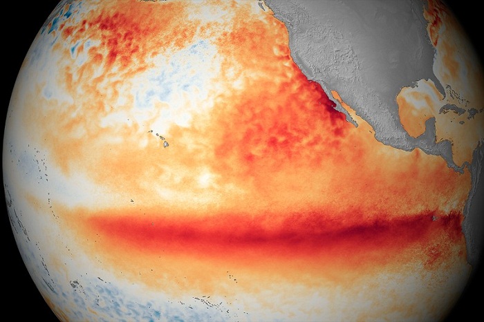
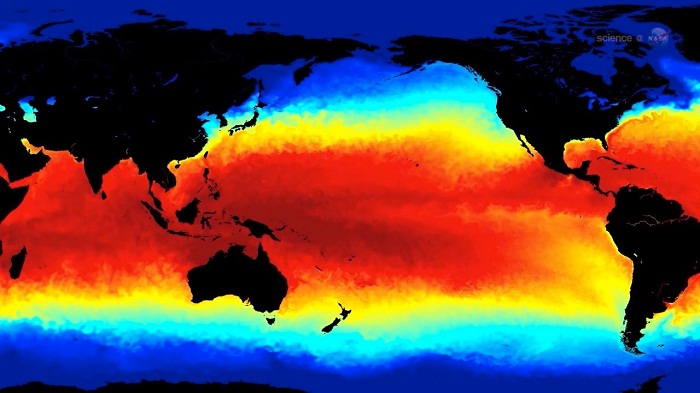
El Niño occurs when warm water that has piled up around Australia and Indonesia spills out east across the Pacific Ocean towards the Americas, taking the rain with it.
A key measure of its intensity is the warmth of water in the central Pacific. In 1997, at its peak on 26 November, it was 2.8 °C above average. According to the latest measurements, it reached 2.8 °C on 4 November this year, and went on to hit 3.1 °C on 18 November – the highest temperatures ever seen in this region.

“The El Niño community is closely watching the evolution [of this El Niño] and whether the current event will surpass the 1997-8 event,” says Axel Timmerman at the University of Hawaii in Honolulu. “Monthly and weekly central Pacific temperature anomalies clearly show that this current event has surpassed it.”
The temperatures in the central Pacific have the biggest impact on the global atmospheric circulation, and therefore the biggest impacts on global weather, says Timmerman, who has been warning that this El Niño is likely to be a record-breaker.
The event hasn’t broken temperature records across the entire eastern Pacific, but in the central eastern Pacific. “It’s shifted into an area where most likely the atmosphere will respond even more,” Timmerman says.
Timmerman and others showed in 2013 that El Niños have been stronger in the last few decades than in any period over the past four centuries. It is unknown whether that’s because of climate change, but Timmerman and colleagues have also shown that extreme impacts from El Niño’s will double in frequency this century as a result of climate change.
In similar findings, Scott Power at the Bureau of Meteorology in Australia and colleagues showed that climate change will amplify the way that El Niño redistributes rainfall, making droughts and floods worse.
Record breaker
El Niño has been implicated in a host of extreme weather events across the globe. Combined with global warming, it’s partly responsible for 2015 being the hottest year on record. In India, more than 2000 people died in a heatwave caused by a delayed monsoon – an effect of El Niño.
Now the region is experiencing unusually heavy rains as the monsoon has finally arrived – also an expected impact of El Niño. “Southern India is having a lot of rain as it goes into winter, having come out of the dry monsoon. This is only so during extreme El Niño, so it is a confirmation that the El Niño is huge,” says Wenju Cai at Australia’s government scientific research body, CSIRO in Melbourne.
El Niño is also probably making record-breaking illegal fires in Indonesia worse, by reducing rainfall there.

Australia has dodged some of the worst effects of El Niño, as the Indian Ocean Dipole – an oscillation of sea temperatures in the Indian Ocean – which was amplifying El Niño, has eased off. And because of the location of the warmest water, some regions like Peru and Ecuador are also likely to experience fewer impacts.
But overall, Timmerman suspects that the impacts of this record-breaking El Niño will be record-breaking too.
Many of the effects are yet to come. For example, whether it will bring rains to California and relieve the drought – or even whether it will go too far and cause floods – isn’t yet known. Timmerman says the models are predicting a higher chance of rain for California.
And once the El Niño is over, it might not be time for celebration, since it’s likely to be followed by a strong La Niña, which will bring roughly opposite effects to the world’s weather. La Nina’s are also expected to be about twice as common as a result of climate change this century.
More about:


